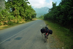
There is a main road going parallel to Mekong from South to North of Laos. It is a very nice, new asphalt road not too busy and I biked on this road for one day, covering the record distance of 135 km. But still this is the main road in the country. I wanted to experience a bit more quite Laos. So I decided to follow other road that was 100 km more east and was parallel to the main road. I chosen the road going from Salavan-Nalangngen – XeLanong–Phin-Xethamouak–Phongsavag-Namon-Mahaxai - Thakhek. This road on the German map was also marked in red like as a National road, the same as the main road, but I hopped that it will be a bit less busy from the main road.
I already got my lesson in Sikkim and in Cambodia that one should not entirely trust maps. I gathered information from additional three different sources about this road:
- In Tat Lo I had seen another map, where this road was marked as a provincial road with annotation that there were two bridges missing.
- I asked the local person that was renting a motorbikes and he told me that this road could be challenging for biking/motorbiking. But he did not know anything about the missing bridges and advised me to go to the tourist information in Salavan, which was on my way.
- In the tourist information they told me that it was an asphalt road all the way, and that there are no missing bridges.
Four sources, four different info. The information that I gathered were a bit contradictory, but at least all were confirming that there should have been kind of the road. Eventual missing bridges should not have been a problem, since I was going by bicycle, and I was sure that in case I would have needed to cross the river, I would have taken local boat.
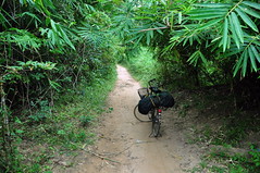
And here is the quiz: find a difference between those two roads, which were both marked as National Roads on my map:
CSC_9487
Less frequently used road also marked
as National Road on the map.
Indeed two bridges were missing on the road. Both were bombed in 1964... Both missing bridges were very solid and I really believe that this was important road before 1964, but I guess the German map was based on a bit old information...
I have to say that I lost the complete trust in German maps...
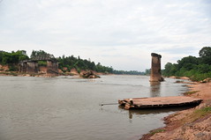
CSC_9510
Missing bridge number 2.
About my adventures on this road you can read next story - Ultimate Jungle Experience.
Below some technical details about 1G road Salavan – Phin.
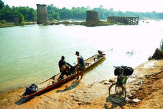
In Salavan one has to go in direction to Pakse for 10km, in the Nathon village one should turn North on to the dirt road. The first missing bridge is on Xe Don (Se Done) around 15 km from the turn. There is a local ferry connecting both sides of the river. Next 50 km is fine dirt road, afterwards, there is a stretch of about 30 km of jungle overgrown road. Several times there is need to cross small rivers – no bridges. There are almost no villages and some parts were impossible to bicycle: too sandy and the many bamboo were growing too close over the road – I was too high to fit under the jungle. I believe that this stretch is almost impossible to go in the wet season. There is a second bridge missing on the Xe Banghiang. The road gets much better 20 km before this river. It is very easy to cross the river on the local boat. There is very nice dirt road straight to Phin after crossing the river.
No comments:
Post a Comment